LoRa
AIS Station
I also run an AIS station which helps fill coastal blind spots and feeds local vessel movements into the global tracking grid.
ADS-B Station
ADS-B (Automatic Dependent Surveillance–Broadcast) is an unencrypted, public aviation tracking protocol used by aircraft to broadcast their real-time location, altitude, and flight telemetry.
Think of ADS-B like an open beacon transmitted directly from an aircraft's onboard navigation systems.
Instead of relying solely on traditional ground radar to sweep and scan the sky above, aircraft continuously broadcast radio signals on 1090 MHz containing precise GPS positions and other data. Local receiver setups like mine - connected to a Raspberry Pi - capture these signals directly from the air as planes fly above.
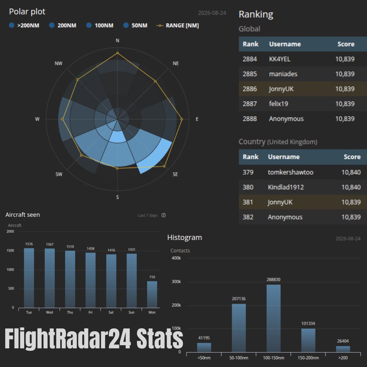
When a signal is received, the raw telemetry is decoded locally and fed directly to global tracking networks like FlightRadar24 and AirNav Radar. This data is combined with feeds from thousands of other volunteer receiver stations around the world to build a real-time, global picture of air traffic.
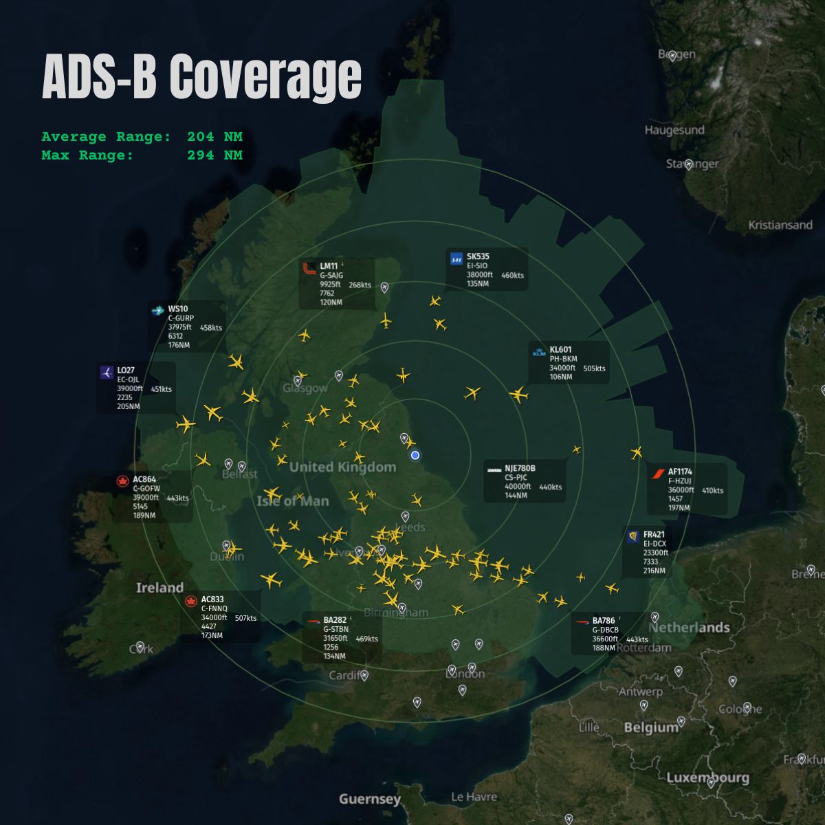
Because it operates on high-frequency line-of-sight radio waves, I have installed my antenna on the apex of the house at around 105m above MSL, as a well-placed antenna can track aircraft hundreds of miles away (I have tracked aircraft across the UK, Northern Ireland and the Netherlands), receiving rapid status updates directly from transponders in mid-flight. My setup ensures I provide continuous coverage and feed local low-altitude and high-altitude air traffic data into the global network.
Unlike cellular network tracking, this radio data is picked up directly from the sky, allowing stations like mine and other flight tracking platforms to process live air traffic independently of commercial flight control infrastructure.
AirNav Radar Station Coverage
FlightRadar24 Stats
What is in an ADS-B Packet?
- Aircraft Identification & Metadata
- ICAO 24-bit Address: Unique hex code assigned to the airframe (acting as its network ID).
- Flight Callsign / Ident: Flight number or aircraft registration (e.g., BAW123, G-ABCD).
- Emitter Category: Type and size classification (e.g., Light, Heavy, Rotorcraft, Glider, UAV).
- Position & Altitude Data
- Latitude & Longitude: Precise GPS coordinates derived from onboard GNSS.
- Barometric Altitude: Pressure altitude referenced to 1013.25 hPa (QNE).
- Geometric (GPS) Altitude: Height above the WGS84 ellipsoid.
- Navigation Integrity & Accuracy: Quality indicators showing GPS precision bounds (NIC, NACp, SIL).
- Velocity & Vector Data
- Ground Speed: Speed relative to the earth's surface.
- Airspeed: Indicated Airspeed (IAS) or True Airspeed (TAS) where available.
- Ground Track / Magnetic Heading: Direction of movement or aircraft nose orientation.
- Vertical Speed: Rate of climb or descent (both barometric and geometric).
- Status & System Safety
- Squawk Code: 4-digit octal transponder code (e.g., 7000 for VFR, 7700 for Emergency).
- Emergency / Priority Status: Alerts for general emergency, lost comms, pan-pan, or fuel state.
- TCAS / ACAS Resolution Advisories: Active collision avoidance system climb/descend instructions.